Abbeville Communal Cemetery Extension
Abbeville, Departement de la Somme, Picardie, France
About
-
- Cemetery ID:
Members have Contributed
Advertisement
Photos


The town of Abbeville is on the main road from Paris to Boulogne (N1), about 80 kilometres south of Boulogne. The Communal Cemetery and Communal Cemetery Extension are located on the left hand side of the road when leaving the town in a north-east direction for Drucat. CWGC direction signs will be found within the cemetery. Enter the Communal Cemetery by the left hand side main gate and follow CWGC signs within the Cemetery.
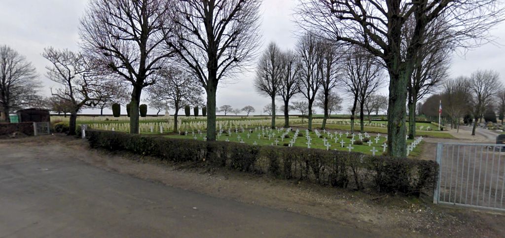
For much of the First World War, Abbeville was headquarters of the Commonwealth lines of communication and No. 3 BRCS, No. 5 and No. 2 Stationary Hospitals were stationed there variously from October 1914 to January 1920. The Communal Cemetery was used for burials from November 1914 to September 1916, the earliest being made among the French military graves. The Extension was begun in September 1916. During the early part of the Second World War, Abbeville was a major operational aerodrome, but the town fell to the Germans at the end of May 1940. On 4 June, an attempt was made by the 51st Division, in conjunction with the French, to break the German bridgehead, but without success. Towards the end of 1943, eight large ski shaped buildings appeared near Abbeville. These proved to be storage units for flying bomb components an they were heavily bombed by Commonwealth air forces.
Abbeville was retaken on 4 September 1944 by Canadian and Polish units. Abbeville Communal Cemetery contains 774 Commonwealth burials of First World War and 30 from the Second. The Extension contains 1754 First World War burials and 348 from the Second. The Commonwealth sections of both cemetery and extension were designed by Sir Reginald Blomfield.
The town of Abbeville is on the main road from Paris to Boulogne (N1), about 80 kilometres south of Boulogne. The Communal Cemetery and Communal Cemetery Extension are located on the left hand side of the road when leaving the town in a north-east direction for Drucat. CWGC direction signs will be found within the cemetery. Enter the Communal Cemetery by the left hand side main gate and follow CWGC signs within the Cemetery.
For much of the First World War, Abbeville was headquarters of the Commonwealth lines of communication and No. 3 BRCS, No. 5 and No. 2 Stationary Hospitals were stationed there variously from October 1914 to January 1920. The Communal Cemetery was used for burials from November 1914 to September 1916, the earliest being made among the French military graves. The Extension was begun in September 1916. During the early part of the Second World War, Abbeville was a major operational aerodrome, but the town fell to the Germans at the end of May 1940. On 4 June, an attempt was made by the 51st Division, in conjunction with the French, to break the German bridgehead, but without success. Towards the end of 1943, eight large ski shaped buildings appeared near Abbeville. These proved to be storage units for flying bomb components an they were heavily bombed by Commonwealth air forces.
Abbeville was retaken on 4 September 1944 by Canadian and Polish units. Abbeville Communal Cemetery contains 774 Commonwealth burials of First World War and 30 from the Second. The Extension contains 1754 First World War burials and 348 from the Second. The Commonwealth sections of both cemetery and extension were designed by Sir Reginald Blomfield.
Nearby cemeteries

Abbeville, Departement de la Somme, Picardie, France
- Total memorials808
- Percent photographed33%
- Percent with GPS5%
Abbeville, Departement de la Somme, Picardie, France
- Total memorials19
- Percent photographed5%
- Percent with GPS0%
Abbeville, Departement de la Somme, Picardie, France
- Total memorials1
- Percent photographed100%
- Percent with GPS0%
Abbeville, Departement de la Somme, Picardie, France
- Total memorials2
- Percent photographed0%
- Added: 14 Jan 2007
- Find a Grave Cemetery ID: 2203025

Cemetery Photos
This is a carousel with slides. Use Next and Previous buttons to navigate, or jump to a slide with the slide dots. Use Escape keyboard button or the Close button to close the carousel.


Success
Uploading...
Waiting...
Failed
This photo was not uploaded because this cemetery already has 20 photos
This photo was not uploaded because you have already uploaded 5 photos to this cemetery
This photo was not uploaded because you have already uploaded 5 photos to this cemetery
Invalid File Type
Birth and death years unknown.
1 photo picked...
2 photos picked...
Uploading 1 Photo
Uploading 2 Photos
1 Photo Uploaded
2 Photos Uploaded
Size exceeded
Too many photos have been uploaded
"Unsupported file type"
• ##count## of 0 memorials with GPS displayed. Double click on map to view more.No cemeteries found